What name would sound more intriguing than Rocky Mountain House? At RMH, European and First Nations cultures came together peacefully to trade. David Thompson, one of Canada’s greatest explorers, used RMH as his base. The day we spent there and then drove to Jasper, Alberta, was one of the most enjoyable days of my life.
Videos by TravelAwaits
(Banff and Jasper national parks made our list of the 10 Best National Parks Outside The U.S.)
When Dad asked me to plan a trip to Alberta to visit his sister, I added RMH to our itinerary because both Thompson and the fur trade fascinate me. But what I found was far more than a simple history lesson. A mistake gave us a different look at RMH. Adding a massive bonus, a lightly trafficked highway provided close encounters with wildlife on our way to the Icefields Parkway via Saskatchewan Crossing. The route is one of our best day trips from Calgary.

The Canoe That Went From RMH To Montréal For A Party
When we visited RMH National Historic Site, I expected the standard living history museum. Instead of taking us to the front entrance on Highway 11A, Cindy, our GPS, directed us toward RMH’s rear entrance. Under her direction, we wandered around on township roads, while wondering why a national historic site was on unpaved roads.
The rear entrance takes visitors to the North Saskatchewan River’s banks, where we met a kayaker and his dog. We parked in a small unpaved lot. Other than the kayaker, we saw no one. The kayaker ignored us, but the dog brought my dad a walking stick. He used it for the rest of the trip.
After a tailgating picnic, we saw Alberta’s Centennial Canoe, the David Thompson. It hangs from the wall in a long kiosk. The kiosk explains about the Centennial Voyageur Canoe Pageant, which had launched from RMH in 1967, Canada’s confederation centennial. Like the voyageurs of old, teams had paddled, towed, and carried their canoes to Montréal. One hundred four days later, Manitoba won the contest.

Appreciating David Thompson’s Achievements At RMH
Next up, a beautiful trail led us to a metal frame showing the outlines of Acton House, a trading fort from 1799 to 1821. RMH served as a trade hub for Blackfoot, Peigan, Blood, Stoney, Sarcee, Gros Ventre, and Cree First Nations.
We wondered if the kiosk, frame, and trail were all that RMH offered. The situation was eerie. All we could do was follow the trail. I eagerly climbed the bison overlook tower, but the bison were too far away to see well. The trail passed historic markers and then a tipi in a clearing. But we saw no people.
At one marker, we discovered that we were walking the David Thompson Trail. The marker explained Thompson’s role at RMH. Thompson used RMH as a base camp for his epic explorations. Thompson explored an arc from the Great Lakes to the Pacific, reaching far into the north. In 28 years of exploring, Thompson had covered 55,000 miles and had surveyed 1.9 million square miles of wilderness. His family accompanied him on many of his journeys. And when he returned to the east, his wife Charlotte Small went with him, in contrast to many traders who abandoned their “country wives.”
To put Thompson’s achievements in perspective, compare him to Meriwether Lewis and William Clark. They led the Corps of Discovery for 8,000 miles during a little more than two-year journey. And the Americans relied on at least one of Thompson’s maps.
The Thompson Trail follows a wide upper level path and a narrow, dirt lower level path. The lower level includes stairs and goes through a forest. Part of it overlooks the river. The sounds of aspen leaves rustling and the running river water would make a perfect relaxation playlist.

Bannocks And A Log Easy Chair At The Métis Village
At the Métis village, a docent was frying bannocks (Scottish skillet bread). They smelled delicious. Seeing that the docent was busy, I entered a large white trapper’s tent where a giant bearskin resting on a bed greeted me. I didn’t expect to come face to face with a bear. And then I noticed the mountain lion on the floor. All I needed was a tiger. Oh, my. Do badger and beaver skins count?
As I talked with the docent, I heard my aunt’s voice. “I wonder where Roxie went.” After they learned about the tent’s contents, we went back outside and enjoyed some bannocks. Someone had turned a log into a chair, which Aunt Deanna sat in. She said it was quite comfortable. We could have made a drum or a dreamcatcher, but time was pressing. The parkway was calling.
Joining the Chimney Trail, we passed the Red River carts that oxen towed on the freight trails. I pitied the oxen. Dad posed as a voyageur in the York boat with Aunt Deanna as a passenger.
As we neared the visitors center, we saw a play fort, which looked like full-size Lincoln Logs. We walked through the fort and rushed through the visitors center. In the center, look for the trading post complete with Hudson Bay blankets.
Even though Cindy sent us to the back way, she had actually sent us through the best way.

On The David Thompson Highway
When we finally left RMH, we had almost 2 hours to go before reaching Saskatchewan Crossing and another hour to Jasper.
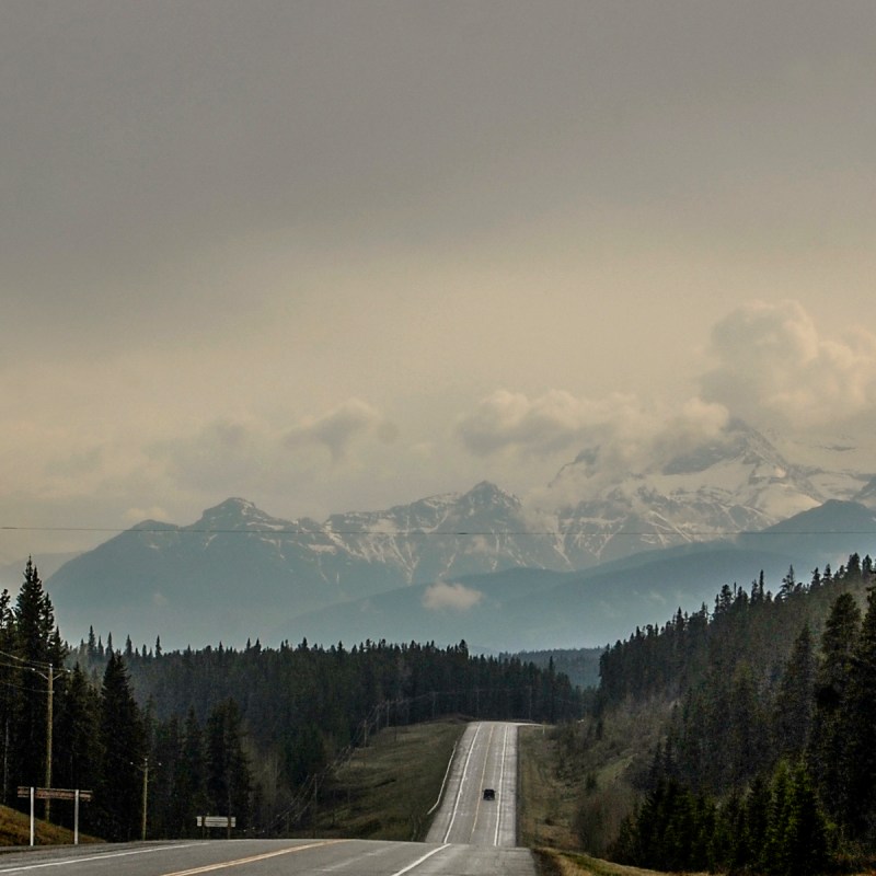
While RMH was wonderful, the true wonders lay ahead of us. During our 2-hour drive, we saw one other car. Other than the road and its associated structures, we seemed to be in an Eden. The mountains, backlit by the sinking sun, beckoned us to come. The aspens gradually gave way to evergreens, and the mountains grew ever larger.
Pro Tip: Sylvan Star Cheese farm is near the eastern end of the David Thompson Highway. I wrote about a trip to Sylvan Star here.

Bighorn Sheep By The Shores Of Abraham Lake
Mount Michener with its distinctive horn stands above Abraham Lake. Canada named it for Governor General Daniel Michener, not the American author James Michener.
The lake is most famous for its spectacular methane bubbles that form in the winter. When Bighorn Dam formed Abraham Lake, the water-covered vegetation on the lake bottom. As the vegetation decays, it releases methane. Winter’s ice traps the methane and creates bubbles. As winter advances and the ice thickens, the bubbles stack, creating sculptures below the water level.
When we came in early June, the snow-streaked dark blue mountain above the turquoise lake was stunning. We pulled over to stretch our legs and enjoy the view.
But what happened next was even more stunning. As we were walking across the highway, a herd of bighorn sheep swept down from a cliff above our van. They ran across the road to a gravel beach next to the lake. As we quietly watched, the sheep and lambs played and grazed within a few feet of us. Some came toward us and watched these strange beings who had invaded their beach before turning away.
After about 20 minutes of sheer delight, the bighorns ran across the road and disappeared up the cliff. When they left, we felt as if we had awakened from a lovely dream.
Pro Tips: If we had known about Miner’s Cafe in Nordegg, northeast of Abraham Lake, we would have eaten some of its famous pies. But then we would have missed the bighorns. Nordegg prospered during the first half of the 20th century because its colliery produced coal for steam engines. Now the colliery is a national historic site.

Watching The Sunset As Highway 11 Turns West
The daylight was passing when the road curled west toward Saskatchewan Crossing, where the David Thompson Highway meets the Icefields Parkway. The sun inched its way toward its rest behind the broken teeth of the Canadian Rockies. The sight took our breaths away.
Pro Tip: For high adventure, climb the heights on the Great Divide Trail from Saskatchewan Crossing to Jasper.
The Braided River At Saskatchewan Crossing
The North Saskatchewan River rises in the Rockies and runs 1,600 miles to Lake Winnipeg. At the crossing, the Howse and Mistaya rivers empty into North Saskatchewan. To see the pass and the turquoise braided river, turn south on Highway 93 to the Howse Pass viewpoint.
At the intersection, we turned north toward Jasper. After passing Bridal Veil Falls, we saw a few more bighorns on the roadside. They also posed for us. As the sun slipped behind the western peaks, the last rays of the sun set the eastern peaks afire. Another magical moment.
One Final Wonder, A Race With An Elk On The Icefields Parkway
Shortly before the sun’s rays dropped below the mountains, a bull elk decided to race us — or chase us away. We couldn’t decide which. For a short distance, he ran with us. He came so close that I could only get his head in my viewfinder. I felt as if I was in a delightful enchantment.

In Jasper At Last
By the time we reached Jasper, the stars were out. We saw them reflected in Jasper’s rivers and lakes. The city works hard to preserve its dark skies, and the streetlights provide gentle illumination. Even in town, we could see the lights above. We stayed at the Marmot Lodge on Jasper’s northern end.
The day had been long, but I wouldn’t trade a single second of it. Seeing these wonders with my dad and my aunt was an experience that I forever will cherish.
After a delicious breakfast the next morning, we were ready to head south on the Icefields Parkway.
Before leaving Jasper, we stopped at a grocery store for tailgating supplies and filled up. Next up, Athabasca and Sunwapta Falls!
Pro Tip
Before you go west on Highway 11, fill up in the city of Rocky Mountain House, 4 miles east of RMH National Historic Site. Gas is generally more expensive in Nordegg and at Saskatchewan Crossing. After the crossing, the next opportunity to fill up is in either Banff (southbound) or Jasper (northbound).
Consider these other Calgary road trips:
